[Home] [Databases] [World Law] [Multidatabase Search] [Help] [Feedback] | ||
England and Wales High Court (Administrative Court) Decisions |
||
You are here: BAILII >> Databases >> England and Wales High Court (Administrative Court) Decisions >> Trail Riders Fellowship v Secretary of State for the Environment, Food And Rural Affairs (Rev 1) [2017] EWHC 1866 (Admin) (18 July 2017) URL: http://www.bailii.org/ew/cases/EWHC/Admin/2017/1866.html Cite as: [2017] EWHC 1866 (Admin), [2017] WLR(D) 484, [2018] PTSR 15 |
[New search] [Printable PDF version] [View ICLR summary: [2017] WLR(D) 484] [Buy ICLR report: [2018] PTSR 15] [Help]
QUEEN'S BENCH DIVISION
THE ADMINISTRATIVE COURT
Strand London WC2A 2LL |
||
B e f o r e :
____________________
TRAIL RIDERS FELLOWSHIP | Claimant | |
v | ||
SECRETARY OF STATE FOR THE ENVIRONMENT, FOOD AND RURAL AFFAIRS | Defendant |
____________________
WordWave International Limited
Trading as DTI
8th Floor, 165 Fleet Street, London EC4A 2DY
Tel No: 020 7404 1400 Fax No: 020 7404 1424
(Official Shorthand Writers to the Court)
Mr Mark Westmoreland Smith (instructed by the Government Legal Department) appeared on behalf of the Defendant
____________________
Crown Copyright ©
MR JUSTICE HOLMAN:
The essential facts and the issue
"to preserve the full status of vehicular 'green lanes' and the rights of motorcyclists and others to use them as a legitimate part of the access network of the countryside ..."
The statutory framework
(i) Definitive map and statement
"(c) the discovery by the authority of evidence which ... shows -
(i) that a right of way which is not shown in the map and statement subsists or is reasonably alleged to subsist ...;
(ii) that a highway shown in the map and statement as a highway of a particular description ought to be there shown as a highway of a different description; ..."
(ii) List of streets
"The council of every county ... shall cause to be made, and shall keep corrected up to date, a list of the streets within their area which are highways maintainable at the public expense."
(iii) The Natural Environment and Rural Communities Act 2006 and the extinction of certain rights of way for mechanically propelled vehicles
"67. Ending of certain existing unrecorded public rights of way
(1) An existing public right of way for mechanically propelled vehicles is extinguished if it is over a way which, immediately before commencement -
(a) was not shown in a definitive map or statement, or
(b) ...
But this is subject to subsections (2) to (8).
(2) Subsection (1) does not apply to an existing public right of way if -
(a) ...
(b) immediately before commencement it was not shown in a definitive map and statement but was shown in a list required to be kept under section 36(6) of the Highways Act 1980 (list of highways maintainable at public expense)
..."
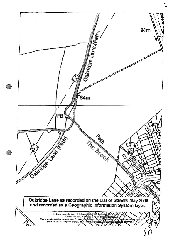
The list of streets
The decision of the inspector
"12. Taking together the historic documentary evidence summarised above, I agree with the parties that public carriageway rights exist over Oakridge Lane. It has existed as a through route since at least 1766. The 1898 Main Roads Order and 1910 Finance Act Map point to it being a public vehicular way and the County Maps, OS, DMS and other records are not inconsistent with that status."
The reasoning of the inspector
" ... that the LoS was designed to be a record of maintenance, that it fulfils a different role to that of the DMS, and its application to the 2006 Act could not have been envisaged when the 1980 Act was drawn up."
"Some guidance, however, is to be found in Fortune (at paragraph 1135 of the judgment) that it is the responsibility of the Highway Authority to decide how best to make and keep corrected up to date its own section 36(6) list."
"18. With that in mind, and in the absence of any requirements in the legislation as to what form the LoS should take, it follows that I must have regard to what the Council says is its LoS (paragraph 16). Therefore I do not share Mr Kind's view that the details contained in the GIS layer are irrelevant. The GIS layer forms an integral part of what the Council regards as its LoS. As regards Oakridge Lane the descriptive element of the LoS gives details of the length of roads defined by start and end points together with other relevant information, and the mapping element shows its alignment. The essence of Mr Westley's argument is that Oakridge Lane was shown on the LoS in 2006, notwithstanding that the entry on that List required correction. However, whilst it might have been the Council's intention to record the historic alignment of Oakridge Lane, it does not alter the fact that immediately before 2 May 2006, the alignment recorded between points C and E was different to the historic route ...
19. I recognise that earlier records included Oakridge Lane as a publicly maintainable highway long before 2 May 2006 ... However, the question is whether the Order route was shown on the LoS immediately prior to this date, not what was shown before then or after, or what should have been shown. It follows that I do not share the view that the statutory purpose would be frustrated if vehicular rights were extinguished merely because of inaccurate particulars of alignment.
20 ... I have concluded that the List kept by the Council for the purposes of the 1980 Act and relevant to the provisions of the 2006 Act contain both a database and a GIS layer which should be read together.
21 ...
22 ...
23. The length C-E is some 110 metres which represents some 10% of the Order route. I agree with the Council that this is not insignificant such that it could be regarded as a minor discrepancy or departure. As regards a sideways displacement ... the routes are close together towards point C but the divergence more pronounced towards E. To a degree, the issue depends on the map scale as to how easy it is to distinguish between the two. However, the Council argue the difference between the routes is clearly distinguishable on a 1:10,000 map, this being the scale of their Definitive Map. I am not persuaded that any difference between the two routes can be regarded as sufficiently minor such that the section C-D should be recorded as a Byway. I therefore conclude that whilst Oakridge Lane was recorded in the LoS, it was shown on a sufficiently different alignment between C and E immediately before 2 May 2006. It follows that the exception cannot apply to this length of the Order route which should therefore be recorded as a Restricted Byway."
Analysis
Outcome
[END OF JUDGMENT]