United Kingdom Statutory Instruments
You are here: BAILII >> Databases >> United Kingdom Statutory Instruments >> The Scottish Adjacent Waters Boundaries Order 1999 No. 1126
URL: https://www.bailii.org/uk/legis/num_reg/1999/uksi_19991126_en.html
|
|
[Home] [Databases] [World Law] [Multidatabase Search] [Help] [Feedback] [DONATE] | |
United Kingdom Statutory Instruments |
||
|
You are here: BAILII >> Databases >> United Kingdom Statutory Instruments >> The Scottish Adjacent Waters Boundaries Order 1999 No. 1126 URL: https://www.bailii.org/uk/legis/num_reg/1999/uksi_19991126_en.html |
||
[New search] [Help]
Statutory Instruments
CONSTITUTIONAL LAW
DEVOLUTION, SCOTLAND
Made
13th April 1999
Coming into force in accordance with article 1
At the Court at Windsor Castle, the 13th day of April 1999
Present,
The Queen's Most Excellent Majesty in Council
Whereas a draft of this Order has been laid before, and approved by a resolution of, each House of Parliament in accordance with section 115(1) of, and paragraphs 1 and 2 of Schedule 7 to, the Scotland Act 1998(1);
Now, therefore, Her Majesty, in exercise of the powers conferred upon Her by section 126(2) of the Scotland Act 1998 is pleased, by and with the advice of Her Privy Council, to order, and it is hereby ordered, as follows:
1. This Order may be cited as the Scottish Adjacent Waters Boundaries Order 1999 and shall come into force on the principal appointed day(2).
2. In this Order-�
"co-ordinate" means a co-ordinate on the Ordnance Survey of Great Britain 1936 Datum;
"line", in relation to any list of co-ordinates in this Order, means a loxodromic line.
3. For the purposes of the Scotland Act 1998, the boundaries between waters which are to be treated as internal waters or territorial sea of the United Kingdom adjacent to Scotland and those which are not, shall be-�
(a)off the east coast of Great Britain, a line joining the co-ordinates set out in Part I of the Schedule to this Order, and
(b)off the west coast of Great Britain a line joining,
(i)the co-ordinates set out in Section 1 of Part II of that Schedule, and then
(ii)the seaward limit of the United Kingdom territorial sea, and then
(iii)the co-ordinates set out in Section 2 of Part II of that Schedule.
4. For the purposes of the Scotland Act 1998, the boundaries between waters which are to be treated as sea within British fishery limits adjacent to Scotland and those which are not, shall be-�
(a)off the east coast of Great Britain,
(i)the line referred to in article 3(a) above, and then
(ii)a line joining the co-ordinates set out in Schedule 2 to this Order.
(b)off the west coast of Great Britain,
(i)the line referred to in article 3(b) above, and then
(ii)the seaward limit of the United Kingdom territorial sea adjacent to Northern Ireland between the following co-ordinates-�
| 55° 26' 37"N | 06° 34' 40"W, and |
| 55° 24' 54"N | 06° 44' 36"W. |
A. K. Galloway
Clerk of the Privy Council
Article 3
| 1. | 55° 48' 42"N | 02° 01' 54"W |
| 2. | 55° 49' 47"N | 01° 59' 58"W |
| 3. | 55° 50' 40"N | 01° 58' 09"W |
| 4. | 55° 50' 44"N | 01° 57' 55"W |
| 5. | 55° 53' 17"N | 01° 48' 28"W |
| 6. | 55° 53' 27"N | 01° 47' 54"W |
| 7. | 55° 55' 01"N | 01° 43' 32"W |
Solway Firth
| 1. | 54° 59' 05"N | 03° 03' 33"W |
| 2. | 54° 58' 18"N | 03° 04' 55"W |
| 3. | 54° 56' 59"N | 03° 08' 29"W |
| 4. | 54° 57' 41"N | 03° 10' 58"W |
| 5. | 54° 57' 39"N | 03° 14' 05"W |
| 6. | 54° 56' 22"N | 03° 20' 48"W |
| 7. | 54° 54' 34"N | 03° 27' 55"W |
| 8. | 54° 49' 11"N | 03° 32' 23"W |
| 9. | 54° 46' 44"N | 03° 38' 12"W |
| 10. | 54° 37' 50"N | 03° 50' 47"W |
Irish Sea
| 11. | 54° 37' 33"N | 03° 51' 05"W |
| 12. | 54° 36' 56"N | 03° 52' 05"W |
| 13. | 54° 36' 07"N | 03° 53' 52"W |
| 14. | 54° 33' 13"N | 04° 00' 11"W |
| 15. | 54° 32' 47"N | 04° 01' 07"W |
| 16. | 54° 31' 51"N | 04° 03' 09"W |
| 17. | 54° 30' 00"N | 04° 04' 25"W |
| 18. | 54° 30' 55"N | 04° 05' 39"W |
| 19. | 54° 33' 02"N | 04° 09' 08"W |
| 20. | 54° 33' 08"N | 04° 10' 35"W |
| 21. | 54° 33' 12"N | 04° 11' 42"W |
| 22. | 54° 33' 07"N | 04° 15' 26"W |
| 23. | 54° 33' 03"N | 04° 17' 30"W |
| 24. | 54° 32' 47"N | 04° 23' 57"W |
| 25. | 54° 32' 31"N | 04° 26' 12"W |
| 26. | 54° 32' 02"N | 04° 29' 24"W |
| 27. | 54° 31' 46"N | 04° 31' 53"W |
| 28. | 54° 31' 10"N | 04° 34' 49"W |
| 29. | 54° 30' 45"N | 04° 36' 48"W |
| 30. | 54° 29' 58"N | 04° 40' 17"W |
| 31. | 54° 29' 01"N | 04° 43' 37"W |
| 32. | 54° 27' 43"N | 04° 47' 32"W |
| 33. | 54° 26' 02"N | 04° 52' 02"W |
| 34. | 54° 27' 52"N | 05° 04' 36"W |
| 35. | 54° 28' 13"N | 05° 05' 08"W |
| 36. | 54° 30' 37"N | 05° 07' 18"W |
| 37. | 54° 31' 56"N | 05° 08' 37"W |
| 38. | 54° 32' 15"N | 05° 08' 57"W |
| 39. | 54° 33' 57"N | 05° 10' 50"W |
| 40. | 54° 36' 22"N | 05° 12' 41"W |
| 41. | 54° 38' 13"N | 05° 13' 43"W |
| 42. | 54° 38' 27"N | 05° 13' 44"W |
North Channel
| 43. | 54° 39' 48"N | 05° 14' 37"W |
| 44. | 54° 40' 39"N | 05° 14' 33"W |
| 45. | 54° 41' 49"N | 05° 14' 49"W |
| 46. | 54° 42' 02"N | 05° 14' 53"W |
| 47. | 54° 42' 50"N | 05° 15' 33"W |
| 48. | 54° 44' 08"N | 05° 16' 48"W |
| 49. | 54° 44' 58"N | 05° 17' 37"W |
| 50. | 54° 46' 37"N | 05° 19' 38"W |
| 51. | 54° 48' 21"N | 05° 21' 50"W |
| 52. | 54° 49' 29"N | 05° 23' 21"W |
| 53. | 54° 49' 51"N | 05° 23' 48"W |
| 54. | 54° 50' 05"N | 05° 24' 11"W |
| 55. | 54° 50' 40"N | 05° 25' 05"W |
| 56. | 54° 51' 22"N | 05° 26' 05"W |
| 57. | 54° 51' 25"N | 05° 26' 08"W |
| 58. | 54° 51' 57"N | 05° 26' 28"W |
| 59. | 54° 52' 40"N | 05° 26' 51"W |
| 60. | 54° 53' 10"N | 05° 27' 07"W |
| 61. | 54° 53' 53"N | 05° 27' 24"W |
| 62. | 54° 54' 19"N | 05° 27' 23"W |
| 63. | 54° 54' 54"N | 05° 27' 44"W |
| 64. | 54° 55' 44"N | 05° 28' 21"W |
| 65. | 54° 55' 59"N | 05° 28' 32"W |
| 66. | 54° 56' 49"N | 05° 29' 13"W |
| 67. | 54° 57' 31"N | 05° 29' 53"W |
| 68. | 54° 57' 53"N | 05° 30' 10"W |
| 69. | 54° 58' 53"N | 05° 31' 05"W |
| 70. | 54° 59' 45"N | 05° 32' 00"W |
| 71. | 55° 00' 31"N | 05° 32' 58"W |
| 72. | 55° 01' 22"N | 05° 34' 12"W |
| 73. | 55° 02' 08"N | 05° 35' 29"W |
| 74. | 55° 02' 48"N | 05° 36' 47"W |
| 75. | 55° 03' 25"N | 05° 38' 13"W |
| 76. | 55° 04' 01"N | 05° 39' 47"W |
| 77. | 55° 04' 29"N | 05° 41' 15"W |
| 78. | 55° 04' 55"N | 05° 42' 53"W |
| 79. | 55° 05' 15"N | 05° 44' 21"W |
| 80. | 55° 05' 30"N | 05° 44' 37"W |
| 81. | 55° 06' 25"N | 05° 45' 46"W |
| 82. | 55° 07' 13"N | 05° 46' 51"W |
| 83. | 55° 08' 05"N | 05° 48' 13"W |
| 84. | 55° 08' 21"N | 05° 48' 41"W |
| 85. | 55° 08' 53"N | 05° 49' 03"W |
| 86. | 55° 09' 57"N | 05° 49' 54"W |
| 87. | 55° 10' 58"N | 05° 50' 50"W |
| 88. | 55° 11' 53"N | 05° 51' 50"W |
| 89. | 55° 12' 41"N | 05° 52' 48"W |
| 90. | 55° 12' 57"N | 05° 53' 11"W |
| 91. | 55° 13' 12"N | 05° 53' 33"W |
| 92. | 55° 13' 46"N | 05° 54' 29"W |
| 93. | 55° 14' 20"N | 05° 55' 08"W |
| 94. | 55° 14' 33"N | 05° 55' 25"W |
| 95. | 55° 15' 04"N | 05° 56' 10"W |
| 96. | 55° 15' 20"N | 05° 56' 35"W |
| 97. | 55° 15' 46"N | 05° 57' 20"W |
| 98. | 55° 16' 07"N | 05° 58' 02"W |
| 99. | 55° 16' 32"N | 05° 58' 56"W |
| 100. | 55° 16' 47"N | 05° 59' 32"W |
| 101. | 55° 17' 03"N | 06° 00' 15"W |
| 102. | 55° 17' 08"N | 06° 00' 27"W |
| 103. | 55° 17' 37"N | 06° 00' 46"W |
| 104. | 55° 18' 16"N | 06° 01' 16"W |
| 105. | 55° 18' 41"N | 06° 01' 38"W |
| 106. | 55° 19' 08"N | 06° 02' 04"W |
| 107. | 55° 19' 10"N | 06° 02' 07"W |
| 108. | 55° 19' 36"N | 06° 02' 34"W |
| 109. | 55° 20' 11"N | 06° 03' 18"W |
| 110. | 55° 20' 15"N | 06° 03' 24"W |
| 111. | 55° 20' 32"N | 06° 03' 47"W |
| 112. | 55° 20' 56"N | 06° 04' 25"W |
| 113. | 55° 21' 16"N | 06° 05' 02"W |
| 114. | 55° 21' 43"N | 06° 05' 57"W |
| 115. | 55° 22' 00"N | 06° 06' 34"W |
| 116. | 55° 22' 07"N | 06° 06' 54"W |
| 117. | 55° 22' 18"N | 06° 07' 22"W |
| 118. | 55° 22' 33"N | 06° 08' 06"W |
| 119. | 55° 22' 45"N | 06° 08' 45"W |
| 120. | 55° 22' 55"N | 06° 09' 12"W |
| 121. | 55° 23' 09"N | 06° 09' 53"W |
| 122. | 55° 23' 22"N | 06° 10' 40"W |
| 123. | 55° 23' 31"N | 06° 11' 13"W |
| 124. | 55° 23' 39"N | 06° 11' 38"W |
| 125. | 55° 23' 59"N | 06° 12' 41"W |
| 126. | 55° 24' 09"N | 06° 13' 16"W |
| 127. | 55° 24' 24"N | 06° 14' 19"W |
| 128. | 55° 24' 26"N | 06° 14' 24"W |
| 129. | 55° 24' 37"N | 06° 15' 16"W |
| 130. | 55° 24' 47"N | 06° 16' 12"W |
| 131. | 55° 24' 49"N | 06° 16' 23"W |
| 132. | 55° 24' 59"N | 06° 17' 16"W |
| 133. | 55° 25' 09"N | 06° 18' 18"W |
| 134. | 55° 25' 16"N | 06° 19' 12"W |
| 135. | 55° 25' 25"N | 06° 20' 28"W |
| 136. | 55° 25' 33"N | 06° 21' 58"W |
| 137. | 55° 25' 35"N | 06° 22' 34"W |
| 138. | 55° 25' 36"N | 06° 22' 53"W |
| 139. | 55° 25' 41"N | 06° 23' 57"W |
| 140. | 55° 25' 44"N | 06° 24' 54"W |
| 141. | 55° 25' 48"N | 06° 26' 52"W |
| 142. | 55° 25' 49"N | 06° 27' 39"W |
| 143. | 55° 25' 49"N | 06° 28' 39"W |
| 144. | 55° 25' 48"N | 06° 29' 56"W |
| 145. | 55° 25' 51"N | 06° 30' 11"W |
| 146. | 55° 25' 54"N | 06° 30' 25"W |
| 147. | 55° 26' 05"N | 06° 31' 23"W |
| 148. | 55° 26' 14"N | 06° 32' 11"W |
| 149. | 55° 26' 22"N | 06° 32' 57"W |
| 150. | 55° 26' 34"N | 06° 34' 15"W |
| 151. | 55° 26' 37"N | 06° 34' 40"W |
Article 4
| 1. | 55° 55' 01'N | 01° 43' 32'W |
| 2. | 55° 56' 00'N | 01° 40' 35'W |
| 3. | 55° 56' 30'N | 01° 38' 54'W |
| 4. | 55° 58' 01'N | 01° 33' 49'W |
| 5. | 56° 01' 54'N | 01° 26' 02'W |
| 6. | 56° 11' 41'N | 01° 11' 20'W |
| 7. | 56° 22' 16'N | 00° 55' 04'W |
| 8. | 56° 23' 39'N | 00° 50' 28'W |
| 9. | 56° 27' 10'N | 00° 38' 41'W |
| 10. | 56° 27' 40'N | 00° 35' 11'W |
| 11. | 56° 30' 12'N | 00° 17' 09'W |
| 12. | 56° 32' 41'N | 00° 01' 51'E |
| 13. | 56° 33' 38'N | 00° 13' 13'E |
| 14. | 56° 34' 39'N | 00° 26' 10'E |
| 15. | 56° 36' 13'N | 00° 47' 53'E |
| 16. | 56° 36' 26'N | 00° 57' 24'E |
| 17. | 56° 36' 32'N | 01° 10' 34'E |
| 18. | 56° 36' 37'N | 01° 30' 00'E |
| 19. | 56° 36' 39'N | 02° 00' 00'E |
| 20. | 56° 36' 33'N | 02° 30' 00'E |
| 21. | 56° 36' 31'N | 02° 36' 26'E |
(This note is not part of the Order)
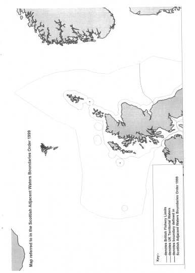
This Order describes for the purposes of the Scotland Act 1998-�
(a)the boundaries between waters which are to be treated as internal waters or territorial sea of the United Kingdom adjacent to Scotland and those which are not (article 3) and
(b)the boundaries between waters which are to be treated as sea within British fishery limits adjacent to Scotland and those which are not (article 4).
A map showing the line of the boundaries for illustrative purposes only is appended to this note.
The pricipal appointed day is 1st July 1999 by virtue of article 3 of the Scotland Act 1998 (Commencement) Order 1998 (S.I. 1998/3178)